1. INTRODUCTION
The question of how much water to pump from a shallow aquifer without
encroaching upon vegetative ecosystems has no straightforward answer.
Excessive or unregulated pumping has the effect of lowering the water table
and negatively impacting the vegetation accustomed to getting its water
from the unsaturated vadose zone or the saturated groundwater zone.
Therefore, enlightened groundwater management
must reach beyond hydrogeology to encompass the closely related
fields of ecohydrology and ecohydroclimatology.
This will prevent the anthropogenic aridization of the ecosystem
and the consequent degradation of the
vegetal cover.
2. GROUNDWATER USE
Societies have pumped groundwater for more than 100 years (Lee, 1915).
Typically, societies resort to groundwater use when all the available surface water is already
committed, or when the use of groundwater is shown to be less costly than that of surface water.
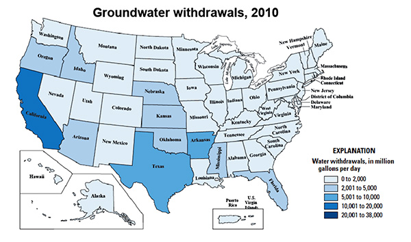
In 2010, fresh groundwater withdrawals in the United States were estimated to be 76 billion gallons per day,
which is 21.4% of the total water use (355 billion gallons per day) (U.S. Geological Survey Circular 1045).
In general, the drier the local climate or the
more developed a society, the greater the use of groundwater. Figure 1 shows groundwater withdrawals in the United
States for the year 2010. It is seen that most of the groundwater use is in the western half of the
country, particularly in California, which has a
highly developed economy, coupled with a prevailing arid/semiarid climate
in a substantial portion of its area.
Almost all water on the surface and subsurface of the Earth originates in direct precipitation.
The fraction of precipitation that manages to infiltrate into the ground, into soil or fractured rock, may follow one of two paths:
In Nature, surface water and groundwater are in constant
movement, interacting in a variety of temporal
and spatial scales. In turn, surface waters may become groundwater, and vice versa.
Surface-water flow is typically fast moving, while groundwater flow is not
(Ponce, 2007).
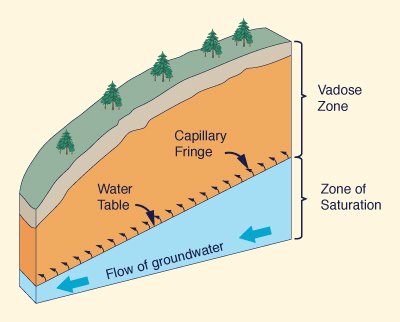
The depth to groundwater is a function of the local geology, geomorphology and climate. In humid climates, the water table lies close to the surface, usually within a few feet; conversely, in arid climates, the depth to groundwater is generally much greater. Typically, the drier the climate, the greater the depth to groundwater. 3. ECOHYDROLOGY All ecosystems need a certain amount of water for their continued survival. Their water needs tend to vary greatly. While some ecosystems thrive with very little water, others require great quantities of it. Nature has made it possible for ecosystems to adapt to whatever water is readily available in the vicinity and to sustain their livelihood on that basis. Recurrent droughts tipically lead to water stress and, if persistent, to the eventual partial or total demise of vegetative communities and ecosystems. However, some ecosystems, such as the chaparral, are able to survive recurrent droughts by developing singular physiological adaptations. In Nature, water, i.e., moisture or humidity, originates in the following five sources:
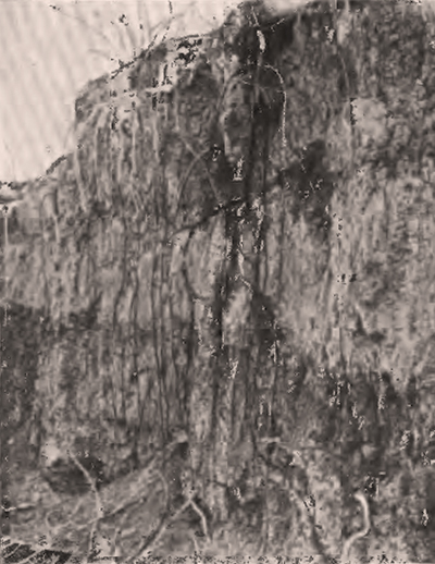
An ecosystem encompasses the characteristic flora and fauna of a certain geographical and climatic region. The key question is: Where does a given ecosystem get its water? The answer is: Where it is more readily available, from any of the five sources listed above. Depending on a variety of factors, the typical ecosystem gets its water from a combination of these sources. In humid systems, they get it primarily from precipitation and surface water; in arid systems, from the near subsurface and groundwater; in superarid regions, from the groundwater, and unusually, from the air. Figure 4 shows the deep roots of the mesquite tree (Prosopis spp.), which can send its roots as much as 50 ft in search for groundwater (Meinzer, 1927). Another example is that of irrigated agriculture, an artificial (that is, anthropogenic) ecosystem which usually gets its water from either surface runoff (reservoirs) or groundwater, by means of pumped wells.
Precipitation is the de facto driver of natural ecosystems.
Mean annual terrestrial precipitation has been estimated at P = 800 mm
(L'vovich, 1979; Ponce et al., 2000).
On the dry side (P < 800), the climate may be classified, with decreasing moisture,
as semiarid, arid, hyperarid, and superarid
Where precipitation is lacking, ecosystems will tap any of the other sources. The primary reliance on only one source makes that ecosystem highly dependent on the permanence/availability of that source, be it: (a) surface water, (b) subsurface water, (c) groundwater, or (d) air. It follows that an ecosystem that normally taps only one source will find it difficult or impossible to survive if the availability of water in that source is somehow reduced or compromised.
4. ECOHYDROCLIMATOLOGY
Most plants draw water freely from the vadose zone, the extent of which depends of soil texture or rock type.
The amount of moisture in the vadose zone is less in arid regions and more in humid regions.
Some plants are able to get their water directly from the groundwater, or else, from the capillary fringe
lying directly above it.
The type and distribution of plants of the Earth's surface is determined by:
Position along the climatic precipitation spectrum, from arid to humid (Ponce et. al., 2000);
Depth to the water table, which determines whether the plants can avail themselves of moisture in the capillary fringe or the groundwater beneath it (Meinzer, 1927);
and
The presence or absence of springs,
which are a function on local geology and
geomorphology (Ponce et. al., 2017).
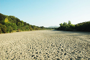
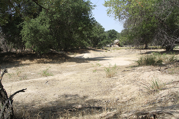
Figure 6 shows a riparian corridor of coast live oak (Quercus agrifolia) in Tierra del Sol,
San Diego County, California. The creek is ephemeral, with surface water flowing
only in response to rainfall.
Yet there is enough year-round moisture in the soil of this semiarid desert to support a healthy riparian corridor.
Depending on local geology and geomorphology, springs may flow into wetlands, enabling
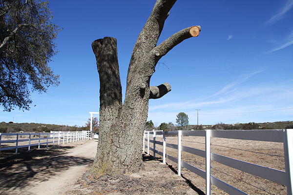
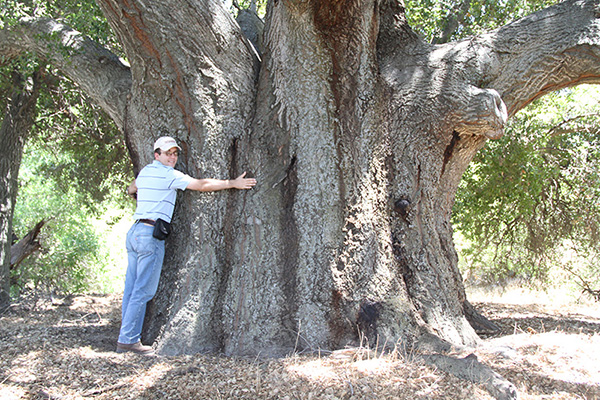
the support of significant stands of vegetation. For instance, Fig. 7 shows a very large specimen of coast live oak
located in the McCain ranch, McCain valley, Boulevard, San Diego County,
California. The specimen, measuring 8 ft in diameter at breast height (24.7 ft in circumference),
is estimated to be at least 300 years old. The absence of this type of vegetation in the
remainder of the arid McCain valley, with 15 in of mean annual precipitation, strongly indicates that this community of coast live oak is being sustained by groundwater originating in
local springs (Ponce, 2013;
Ponce et. al., 2017).
Fig. 7 A very large specimen of coast live oak, Boulevard, California.
5. EFFECT OF GROUNDWATER PUMPING
Groundwater pumping typically produces a cone of depression around the well location
(Theis, 1940;
Ponce, 2006).
The size of the cone of depression depends on the amount of capture, greater amounts corresponding to deeper cones.
The water table and associated capillary fringe are abated as a result of the pumping.
A conflict arises in the event that
the pumped water
is being used by the local ecosystem. Continued abatement of the water table, continuing
in spatial extent and duration,
is bound to impose a hardship on the overlying ecosystem.
In extreme cases, the vegetation could dry out and die as a direct consequence of the
pumping.
Thus, the viability of groundwater pumping is seen to be more associated with ecohydrology than with hydrogeology.
Studies are needed to determine the extent to which a proposed groundwater development will lower the water table and the
effect that this
lowering will have on the livelihood of local vegetation. Indiscriminate groundwater pumping will cause water
stress in local
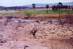
ecosystems, eventually leading to their demise. The resulting effect is poised to be the aridization, i.e., the desertification,
of the landscape, which is reckoned by any standard to constitute a significant
negative impact.
A case in point is that of the dead coast live oak tree
(Quercus agrifolia) in Tierra del Sol, San Diego County, California, shown in Fig. 8.
This tree, whose age is estimated to be at least 100 years old,
died in the year 2014,
presumably due to local moisture stress and the consequences from it
Fig. 8 A dead specimen of coast live oak: Morning Star Ranch, Tierra del Sol,
6. SUMMARY
The perceived societal need to pump groundwater is contrasted with the need of vegetative ecosystems
to avail themselves of water and moisture from a diversity of sources existing in the environment. These are: (a) precipitation,
(b) surface water and surface runoff; (c) subsurface water from the unsaturated zone, (d) groundwater, and (e) the air.
In general, plants choose a combination of these sources for their water needs,
depending on the local climate, geology, and geomorphology.
While some plants use several sources, others may rely primarily on only one source.
Plants heavily dependent on one
source are likely to readily find themselves in moisture stress if that source is substantially
reduced or compromised.
Indiscriminate pumping of groundwater has the potential to negatively affect the livelihood and survival
of vegetative ecosystems that rely primarily on groundwater,
or are heavily dependent on it.
REFERENCES
Lee, C. H. 1915. The determination of safe yield of underground reservoirs of the closed-basin type. Transactions,
American Society of Civil Engineers, Vol. LXXVIII, Paper No. 1315, 148-218.
Meinzer, O. E. 1927.
Plants as indicators of ground water.
U.S. Geological Survey Water Supply Paper 577.
Ponce, V. M., R. P. Pandey, and S. Ercan. 2000. Characterization of drought across climatic spectrum.
Journal of Hydrologic Engineering, ASCE, Vol. 5, No. 2, April, 222-224.
Ponce, V. M. 2006. Groundwater utilization and sustainability. Online article.
Ponce, V. M. 2007. Sustainable yield of groundwater. Online article.
Ponce, V. M. 2013.
Impact of Soitec solar projects on Boulevard and surrounding communities, San Diego County, California. Online article.
Ponce, V. M. 2014.
Effect of groundwater pumping on the health of arid vegetative ecosystems. Online article.
Ponce, V. M., M. I. Diaz, and L. A. Magallon. 2017.
The linear oasis: Ecohydrology of red shank. Online article.
Theis, C. V. 1940.
The source of water derived from wells: Essential factors controlling the response of an aquifer to
development.
Civil Engineering, Vol. 10, No. 5, May, 277-280.
|
| 211104 10:50 |