|
| Source: U.S. Geological Survey |
|
March 2006
1. WATER AND GROUNDWATER
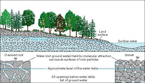
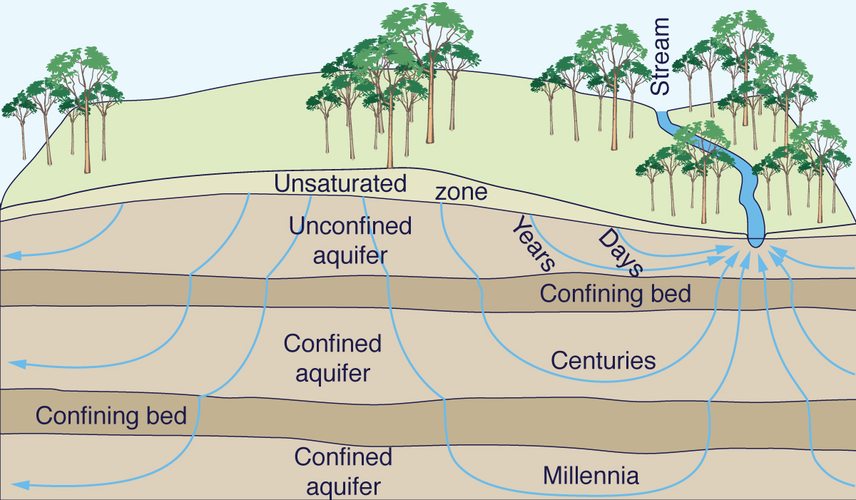
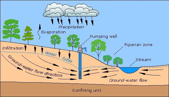
Groundwater is the portion of the Earth's water cycle that flows underground. Groundwater originates from precipitation that percolates into the ground. Percolation is the flow of water through soil and porous/fractured rock. The water table separates the saturated, or aquifer zone, from the unsaturated, or vadose zone, where the water does not fill all the voids or spaces in the soil or rock (Fig. 1). The general trend is for water in the unsaturated zone to move almost vertically downward until it reaches the water table. On the other hand, water in the saturated zone moves primarily along nearly horizontal hydraulic gradients, from higher to lower elevations. The ocean is the natural sink for groundwater flows.
Water is among the most precious of natural resources.
In many regions of the world, the pressures of economic development are producing a surface-water scarcity.
Yet in most places, groundwater may be found within a relatively short distance below the ground surface. The pervasive and seemingly abundant supply of groundwater has led to its indiscriminate and often excessive use. However, this use may have diverse and often wide ranging effects on the local and regional hydrology and ecology. These interdisciplinary aspects of groundwater utilization have brought into question the concept of safe yield, defined as the maintenance of a long-term balance between the amount of withdrawal and the amount of recharge (Sophocleous, 2000). Thus, the issue of groundwater sustainability has arisen (Alley and Leake, 2004). To what extent may a region's groundwater resources be exploited without unduly compromising the principle of sustainable development? Sustainable development is the development that meets the needs of the present without compromising the ability of future generations to meet their own needs (The World Commission on Environment and Development, 1987).
In seeking answers to this question, we must look not only to the discipline of groundwater geology, but also to the synthesis of several related earth sciences. The sustainability of groundwater utilization must be assessed from an interdisciplinary perspective, where hydrology, ecology, geomorphology, and climatology play an important role. This article contributes to establish a solid scientific basis for this synthesis. 2. ORIGIN OF GROUNDWATER
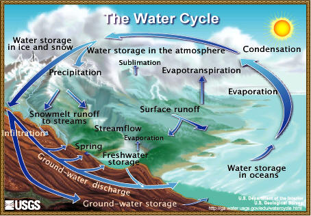
Precipitation is the source of all groundwater, new and old. Precipitation that does not form part of surface runoff or remain on the land surface percolates into the ground. Once there, it can follow three distinct paths (Fig. 2):
|
|
| U.S. Geological Survey |
|
Throughout millennia, groundwater has accumulated underground, slowly seeping through soil and rock, usually in the direction of the closest ocean. [A smaller portion of groundwater accumulates in closed, endorheic drainage basins lying in the interior of continents]. In terms of its flow path and fate, groundwater flow is divided into:
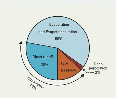
Shallow groundwater flow, or groundwater runoff, intercepts the land surface, feeding springs and seeping back to the surface waters as the perennial flow (baseflow) of streams/rivers and other freshwater bodies, such as swamps and lakes. Conversely, deep groundwater flow, or groundwater runout, does not intercept the land surface, flowing instead directly into the ocean. Shallow percolation is the source of shallow groundwater flow. On a global basis, the annual amount of shallow percolation is equal to the annual amount of baseflow that discharges into streams and rivers (World Water Balance, 1978). Since baseflow constitutes 30% of streamflow, and streamflow is about 40% of precipitation, it follows that baseflow, or shallow percolation, constitutes (0.30 × 0.40) × 100 = 12% of precipitation (L'vovich, 1979).
Deep percolation is the fraction of percolation that reaches the deep groundwater. In terms of volume, deep percolation
is about 5 percent of streamflow (L'vovich, 1979).
Therefore, on an annual global basis, deep percolation constitutes
(0.05 × 0.40) × 100 = 2% of precipitation |
|
|
The amount of deep percolation is of considerable practical
interest from the standpoint of sustainability.
By definition, deep percolation does not belong to the surface waters and, therefore,
it cannot affect their quantity.
On the other hand, shallow percolation is the source of the seepage to surface waters.
Any amount of water extracted from shallow groundwater through well pumping
effectively shortcuts the natural process,
returning to the land surface amounts of groundwater that were going to eventually return to the surface waters anyway.
An exception to the preceding statement is pumping near the sea coast, where shallow groundwater may join the ocean directly.
However, excessive pumping of shallow groundwater near the sea coast may lead to salt-water intrusion.
3. QUANTITY AND QUALITY
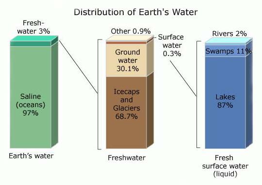
Of all the Earth's water, only 3% is freshwater; the rest is saline (ocean) water.
Of all the freshwater on Earth, 68.7% is permanently stored in icecaps and glaciers,
30.1% is groundwater, 0.3% is surface water, and 0.9% is other minor storage (Fig. 4).
Thus, groundwater is about one-hundred times more plentiful than surface water.
However, while surface water is typically low in salt ions, groundwater, particularly that lying at great depths, may contain high
concentrations of salt ions, effectively limiting its economic use.
Saline groundwaters have concentrations in excess of 1,000 parts per million (ppm).
In the United States, the depth to saline groundwaters varies from less than 500 ft (150 meters) to more than 1,000 ft
(300 meters) (Alley, 2003).
|
|
| U.S. Geological Survey |
|
For comparison purposes, the salinity of freshwaters is less than 500 ppm, while the salinity of ocean waters is about 35,000 ppm. Slightly saline water, for example, irrigation water, has concentrations from 500 to 1,500 ppm, while moderately saline water, such as irrigation drainage water and groundwater, ranges from 1,500 to 5,000 ppm. Highly saline groundwaters may have salinity concentrations in excess of 5,000 ppm. 4. AGE OF GROUNDWATER
Age is a major difference between surface water and groundwater. Surface waters are typically fresh, distinctly new. On a global basis, surface water recycles every 9 to 16 days, with an average of 11 days (World Water Balance, 1978; L'vovich, 1979). Evaporation, evapotranspiration and surface runoff are the agents responsible for the relatively fast recycling of surface water.
Unlike surface water, groundwater does not recycle readily. Rates of groundwater turnover vary from days to years, and from centuries to millennia, depending on aquifer location, type, depth, properties, and connectivity (Fig. 5). The average time for the renewal of groundwater is 1,400 years (World Water Balance, 1978). Shorter renewal times tend to be associated with shallow groundwater, while longer renewal times are associated with deep groundwater. Significantly, renewal rates of deep groundwater are about 1/15 of those of shallow groundwater (Jones, 1997). Some fossil, or paleogroundwaters may have ages exceeding 30,000 years. Carbon dating techniques may be used to estimate the age of fossil groundwaters. These groundwaters are practically nonrenewable; once used, they are not likely to recharge any time soon. |
|
| U.S. Geological Survey |
|
5. RECHARGE AND DISCHARGE
Groundwater levels vary seasonally and annually. They are high at the end of the wet season, and low at the end of the dry season; likewise, they are high at the end of a wet year, and low at the end of one or more dry years (a drought period). Nevertheless, on a long-term basis (decades or centuries), naturally occurring groundwater levels tend to be steady, i.e., they undergo little change.
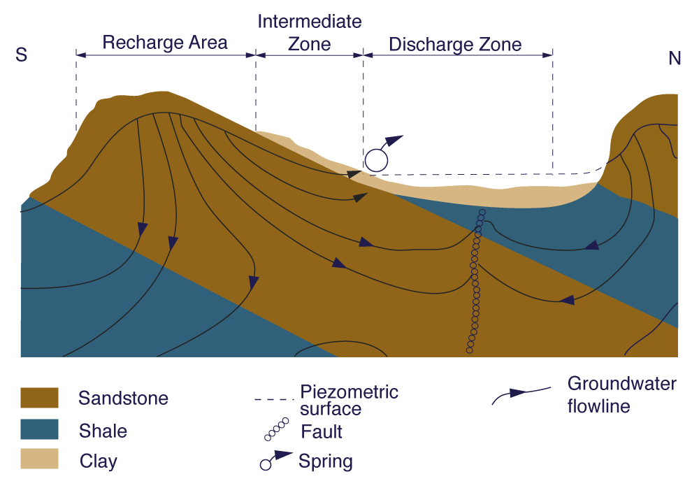
Groundwater is naturally recharged upstream and discharged downstream. Recharge areas are close to mountain peaks, where precipitation
is likely
to be higher than in the adjacent lowlands. Shallow groundwater discharges in the valleys and other low-lying zones of the Earth's crust |
|
| Ministry of Environment, British Columbia |
|
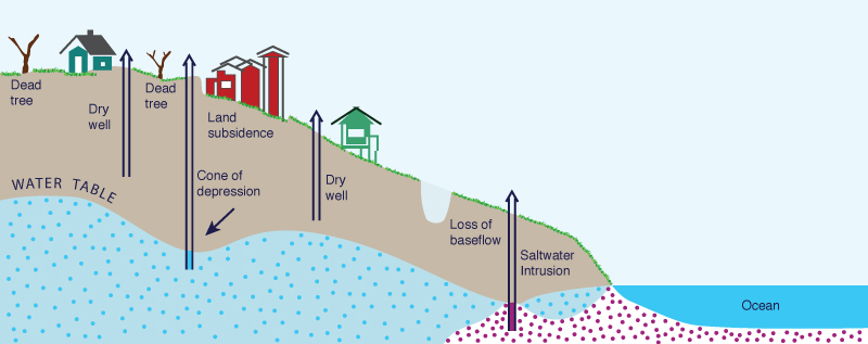
Through human intervention, groundwater is subject to artificial discharge, that is, the process of pumping groundwater from an aquifer to satisfy a socioeconomic need. In some instances, groundwater may also be subject to artificial recharge. Some progressive communities are presently accomplishing the artificial recharge of their aquifers in order to conserve the groundwater resource.
Excessive pumping may lead to groundwater depletion, wherein groundwater is extracted from an aquifer at a rate faster than it can be
replenished. Depletion can have significant effects on surface and unsaturated subsurface (vadose) waters, and on the
terrestrial, riparian, and other ecosystems which depend on these waters.
6. PHYSICAL PROPERTIES
Groundwater flow has two major physical properties: Hydraulic conductivity,
and Specific yield.
Hydraulic conductivity
is the rate at which water flows through porous media
(soil and porous or fractured rock), expressed in velocity units (meters per second; feet per second).
Specific yield is the free-draining pore-water volume, expressed per unit of total volume.
An aquifer with large values of either hydraulic conductivity or specific yield, or both, can release large quantities
of water to wells or springs.
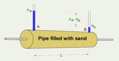
In general, groundwater flow is described by Darcy's Law (Freeze and Cherry, 1979). This law
states that the volumetric flow rate Q through porous media is proportional to
flow area A, hydraulic conductivity K, and hydraulic gradient i (Fig. 7):
in which
The hydraulic conductivity of an aquifer may change with position (heterogeneity) and direction (anisotropy), but generally it does not change with time. The hydraulic gradient, however, may change in time, depending on the season, but more importantly, on the rate of pumping and extent of aquifer depletion. |
|
| Portage County, Wisconsin |
|
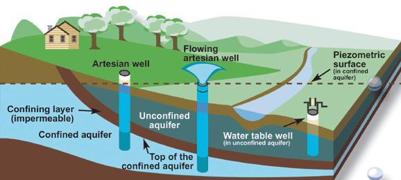
7. AQUIFERS
Depending on their position relative to the ground surface and other permeable or impermeable layers (aquitards),
aquifers are classified into: Unconfined, and Confined. Unconfined aquifers lie near the surface and, for the most part, constitute shallow groundwater. Confined aquifers lie at greater depths, below a confining layer and often under pressure. Confined aquifers may constitute either shallow or deep groundwater, depending on the characteristics of the regional groundwater flow (Fig. 8). In confined aquifers, the specific yield is replaced by the storativity, to reflect the fact that aquifer releases are caused by changes in fluid pressure, and not by actual dewatering of the pore spaces. |
|
| Source: U.S. Geological Survey |
|
Depending on their geologic age, aquifers are classified into:
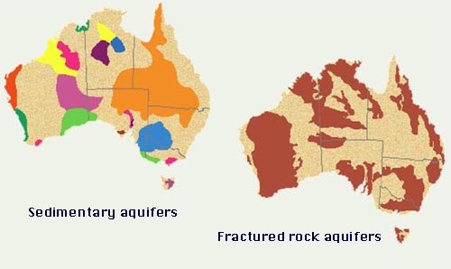
Quaternary, and Tertiary. Quaternary aquifers lie within alluvial, colluvial, glacial, or lacustrine deposits. They consist primarily of unconsolidated materials such as sand and gravel, but may also have some silt and clay. These aquifers are usually superficial; they flow through soils deposited in the valleys and other depressions of the Earth's surface throughout the Quaternary Period (1.6 to 1.8 million years before present). They are either unconfined or confined, and contain, for the most part, shallow groundwater. The hydraulic conductivity and specific yield of quaternary aquifers are usually large compared to those of other aquifers. Tertiary aquifers may lie near the surface or at greater depths, and may be confined or unconfined. They are composed of either sedimentary or fractured rock; or, in some cases, of unconsolidated deposits lying beneath rock. Depending on their depth and connectivity, tertiary aquifers may contain either shallow or deep groundwater, or both.
The hydraulic conductivity of sedimentary aquifers is a function of the rock's porosity.
|
|
| Government of South Australia |
|
Rates of groundwater movement in fractured rock aquifers are difficult to quantify, with yields often being extremely variable and dependent on the distribution of major fractures. For instance, a detailed study of a fractured rock aquifer in the Clare Valley, South Australia, revealed a variability in hydraulic conductivity of ten (10) orders of magnitude, from 102 meters/day in some aquifer pump tests to 10-8 meters/day in tests on the rock cores (Love et al., 2001). Flow velocities and contaminant transport rates in fractures or solution cavities may be high, resulting in early contaminant appearance at target wells or streams and in poor filtration/elimination of pathogens. Knowledge of fracture-flow dynamics and fracture orientation and location is essential, because fractures may cause markedly anisotropic behavior, especially with regard to contaminant transport (National Research Council, 2000). In principle, the flow direction in fractured rock aquifers may differ from the direction of the maximum hydraulic gradient by up to 90o (Love et al, 2001). Thus, preferred flow paths in fractured rock aquifers may cross surficial watershed boundaries, defying conventional hydrological characterization.
8. GROUNDWATER SYSTEMS
A groundwater-flow system may consist of one or more aquifers of different types. The areal extent of groundwater-flow systems varies from a few square miles or less, to tens of thousands of square miles. The length of groundwater-flow paths ranges from a few feet to tens, and sometimes hundreds, of miles. A deep groundwater-flow system with long flow paths between areas of recharge and discharge may be overlain by, and in hydraulic connection with, several shallow, more local, flow systems. Thus, the definition of a groundwater-flow system is, to some extent, subjective and depends in part on the scale of the study (Alley et al., 1999). 9. WELLS
|
|
| Environment Canada |
|
Pumping from a water table well lowers the groundwater levels near the well. The affected zone is known as the cone of depression, and the land surface above it, its area of influence (Fig. 11). Well pumping changes the natural direction and amount of groundwater flow within the area of influence. If two cones of depression overlap, the interference reduces the water available to each well (Fig. 11). Well interference may be a problem when many wells are competing for the water of the same aquifer, particularly at the same depth. |

|
|
In cases where the area of influence of a well extends to a nearby stream or lake, there is a reversal in the flow direction, and the water body begins to lose water to the well by induced recharge. Streams, wetlands, and lakes may dry up completely under sustained conditions of induced recharge. 10. WELL PLANTS
The most outstanding feature of the flora of arid regions is its relation, or lack of relation, to the water table. On one hand are the xerophytes, adapted to extreme economy of water, which depend on the infrequent rain for their livelihood and which, during prolonged periods of drought, maintain themselves in a nearly dormant condition. On the other hand are the phreatophytes, or well plants, which habitually grow where they can send their roots down to the water table, or to the capillary fringe immediately overlying the water table; thus, they are able to obtain a perennial and secure supply of water (Meinzer, 1927).
Depletion of groundwater places at risk the survival of well plants. In turn, the loss of vegetation can produce a
domino effect on the rest of the landscape, with increased erosion,
increase in surface albedo, decreased ambient moisture, and eventually, climate change.
11. GROUNDWATER UTILIZATION
Utilization of an aquifer implies the removal of sizable volumes of groundwater, and this changes the aquifer's
natural recharge and discharge patterns.
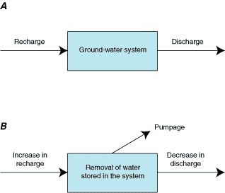
Net recharge is defined as the difference between recharge and discharge. Under pristine, or predevelopment, conditions,
recharge equals discharge, and net recharge is zero (Fig. 12 A).
Under conditions of groundwater development, pumping amounts to artificial discharge. At a given site, the depletion of the aquifer and
its cone of depression may effectively reduce the natural discharge to a value close to zero.
In this case, net recharge is the amount of increased recharge minus the pumpage,
minus the decreased discharge, if the latter is still positive |
|
| Source: U.S. Geological Survey (Circular 1186) |
B. Net recharge under development conditions.
|
In determining the effects of pumping,
it is recognized that not all the water pumped is necessarily consumed.
For example, not all the water pumped for irrigation is consumed by evapotranspiration.
Some of the water returns to the ground-water system as irrigation-return flow.
Most other uses of groundwater are similar in that some of the water pumped is not consumed but is returned to the system.
Thus, it is important to differentiate between the amount of water pumped and the amount of water actually consumed.
The following three scenarios are possible: Pristine, or predevelopment conditions, where the water table remains unchanged in time in the long run,
Development conditions, with moderate rates of withdrawal, where the water table achieves a hydrological
equilibrium at a state somewhat lower
that the original state, and
Development conditions, under intensive withdrawal, where the water table continues to
fall due to groundwater pumping at unsustainable rates.
Under the first scenario, with pristine conditions, the system is in a state of long-term equilibrium, which
supports the local surface water bodies
(streams, rivers, swamps, and lakes) and ecosystems (aquatic, riparian, transitional, and terrestrial).
Under the second scenario, with moderate withdrawal rates, local surface waters and ecosystems are moderately affected.
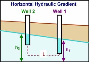
The hydraulic gradient, which is subject to human intervention, controls the flow of groundwater (Darcy's Law).
At a given site, recharge is proportional to the horizontal hydraulic
gradient |
|
| Portage County, Wisconsin |
|
12. GROUNDWATER DEPLETION
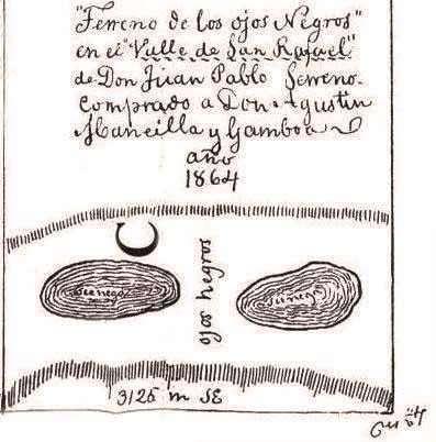
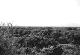
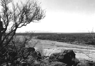
Groundwater depletion has been documented in many instances. A classic case is that of Borrego Valley, in Southern California's high desert, near Borrego Springs, in San Diego County. Water levels in Borrego Valley have declined about 2 feet per year (0.6 meters per year) over the past 20 years. The extracted groundwater is used for intensive agriculture as well as recreation. Another significant example of groundwater depletion is the Ojos Negros valley, in Baja California, Mexico, about 40 kilometers (25 miles) east of Ensenada. In the past 40-50 years, the water table in the valley has dropped up to 45 meters (150 feet). The extracted groundwater is primarily used to support intensive agriculture. The experience of the Ojos Negros valley is particularly sobering, because the valley derives its name (Spanish for "Black Eyes") from two oval-shaped swamps, or "cienagas" (incorrectly spelled "sienega" in Fig. 14), that existed prior to the development of groundwater, and have since dried out and disappeared in the face of protracted aquifer depletion. Other wetlands, near the valley's mouth, have been reduced to a fraction of their original size (Ojos Negros Research Group, 2003). |
|
| Zárate Archives, Ensenada, Mexico |
that gave their name to the Ojos Negros valley,
Baja California, Mexico (dated 1864).
|
In South-central Arizona, groundwater pumping to support population growth, including the Tucson and Phoenix areas, has resulted in water-table drops of between 300 and 500 feet (90 and 150 meters), land subsidence of as much as 12.5 feet (3.8 meters), and significant losses of riparian ecosystems. Figure 15 shows two views of the same reach of the Santa Cruz river at Martinez Hill, south of Tucson. The photo to the left, dated 1942, shows well established stands of mesquite and cottonwood trees along the river banks, indicating that sufficient moisture to support vegetation existed in the soil at that time. The photo to the right, dated 1989, shows that the riparian trees have all but disappeared. Data from two nearby wells indicates that the water table had declined more than 100 feet (30 meters) due to pumping, and this appears to be the principal reason for the decrease in vegetation. The roots of mesquite on the flood plain of the Santa Cruz River have been known to reach depths of 50 to 60 feet (15 to 18 meters) (Meinzer, 1927). |
|
|
| Robert H. Webb, U.S. Geological Survey |
of the Santa Cruz river, south of Tucson, Arizona.
|
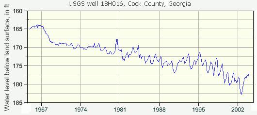
Depletion is not limited to semiarid and arid regions. Intensive pumping can lead to groundwater depletion in some subhumid regions as well. Figure 16 shows the historical record of water levels in a USGS well in Cook County, Georgia. The last 35 years have seen a drop of nearly 15 feet (5 meters). |
|
| U.S. Geological Survey |
|
13. THE TRAGEDY OF THE COMMONS
Groundwater depletion is a logical consequence of a commons (a natural resource used jointly by many stakeholders) exploited in the absence of regulation or sustainable practices. As with any other natural resource held in common, an aquifer tends to be viewed by individuals pursuing their own self-interests as a resource to be exploited before others are able to get to it.
The theoretical framework of the "Tragedy of the Commons" is due to Hardin (1968).
14. IMPACTS OF GROUNDWATER DEPLETION
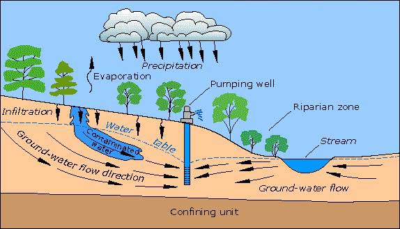
The impacts of groundwater depletion are many and varied. The first and most direct impact is the loss of baseflow. Shallow groundwaters flow nearly horizontally, in the direction of the closest depression in the Earth's crust, usually towards a stream or river draining a valley. Any shallow groundwater extracted through pumping is water that does not reach the surface waters in the vicinity (Fig. 17). |
|
| U.S. Geological Survey |
(losing) towards the pumping well, reducing its baseflow.
|
The impact depends on the intensity of pumpage and the associated loss of baseflow. If baseflow disappears and this may be traced to groundwater pumping, the effects could be far reaching. Therefore, in general, it is necessary to consider the conjunctive use of surface and groundwaters, instead of treating these two resources as separate entities, subject to different management policies (National Research Council, 2000). The interaction between surface and groundwater varies from arid to humid climates. Perennial, or gaining streams, typical of subhumid and humid regions, augment their flow through baseflow. Conversely, ephemeral, or losing streams, typical of arid and semiarid regions, decrease their flow through transmission losses, which are the exact opposite of baseflow (Natural Resources Conservation Service, 2005). Therefore, when a gaining stream is transformed into a losing stream through aquifer depletion, a fraction of surface runoff is converted to shallow groundwater, increasing recharge. Effectively, the hydraulic gradient has been reversed; where originally it flowed into the stream, now it flows out of the stream (Fig. 17). The loss of baseflow can trigger a chain reaction of negative impacts to various components of the landscape. Direct, or primary, impacts to the landscape can be expressed in terms of:
Other impacts related to groundwater depletion include (Fig. 18):
|
|
| U.S. Geological Survey |
|
The impacts of groundwater depletion are pervasive and, in most cases
significant enough to justify a detailed evaluation. A sensible strategy is to develop baseline data
on selected ecosphere components, prior to the proposed groundwater development. These components include:
In the absence of baseline data, it is difficult to ascertain a cause-effect
linkage between groundwater development and its environmental consequences.
The effects of groundwater development tend to become apparent gradually, with time often measured in decades, such as in the case of climate change
(Alley and Leake, 2004).
Other impacts, such as the loss of baseflow,
can become apparent within a shorter timeframe, typically in a few years.
In many instances, it is hard to trace the observed effects of groundwater depletion to actions of the past. Therefore, it is imperative that the impacts of development be carefully assessed and painstakingly monitored. Beginning at the early stages of groundwater development, cause-effect linkages should be established and contingency/mitigation plans drawn up. 15. SUSTAINABLE YIELD
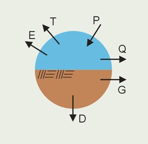
Given that shallow groundwaters are intrinsically connected to the surface waters, it follows that they should not be exploited in an unsustainable manner. It is noted that aquifers may have accumulated their volumes through centuries or millennia. Therefore, a groundwater use policy based on a substantial reduction of aquifer volume would be unsustainable, particularly if the rate of replenishment is slow. A sustainable policy for the exploitation of shallow aquifers should be based not on the existing volume, but on the basin's recharge capacity. For this purpose, a mass balance may be used to evaluate the components of the water cycle, on an annual basis. A groundwater basin's mass balance is (Fig. 19):
in which P = precipitation, E = evaporation (from lakes and other surface-water bodies), T = evapotranspiration (from vegetative ecosystems), Q = surface runoff (direct, or flood runoff), G = groundwater runoff (to baseflow), and D = deep percolation (runout to ocean). |
|
|
A sustainable groundwater management plan should begin by tapping deep percolation
Hydrological and hydrogeological studies are required to accurately estimate percolation amounts on the local and regional scales (National Research Council, 2000). In the absence of these studies, an initial or reference estimate of deep percolation may be based on global hydrology. On a global annual basis, deep percolation is approximately 1/6 of shallow percolation, or baseflow (see Fig. 3). Therefore, deep percolation amounts to 2% of precipitation (L'vovich, 1979).
Using this value as an initial estimate, until detailed basin-specific studies are available,
in which Y = sustainable yield, in units of volume per year, A = recharge surface area, to be taken as the aquifer's geographical area, and P = annual precipitation [depth per year]. For A in square kilometers and P in millimeters per year, the formula for Y, in cubic meters per year, is:
For A in square miles and P in inches per year, the formula for Y, in acre-feet per year, is:
To properly account for annual precipitation variability, the recommended value of P is the average of the past N years of record, in which N is the typical recurrence interval of drought events in the given geographical location. For most regions of practical interest, N varies between 3 and 25 years, being 3-6 years for arid regions, 6-12 years for semiarid regions, and 12-25 years for subhumid regions (Ponce et al., 2000). Groundwater usage beyond the estimate of deep percolation, to include fractions of shallow percolation, would have to show conclusively that it does not adversely affect surface waters and local/regional ecosystems. It would also have to show that it does not cause a significant drop in the water table, which would set the aquifer flow system on an unsustainable course, and that it does not cause wetlands reduction, stream degradation, ground subsidence, climate change, or other negative impacts. 16. SUSTAINABILITY AND WATER QUALITY
Sustainability in water quantity must imply sustainability in water quality.
The human-induced loss of groundwater quality is a pervasive problem in both developed and developing nations.
|
|
| U.S. Geological Survey |
|
In a comprehensive U.S. Geological Survey study,
concentrations of nitrogen in nearly half of the streams sampled
in agricultural areas ranked among the highest of all streams measured. Moreover,
the highest rates of detection for the most heavily used herbicides (atrazine, metolachlor, alachlor, and cyanazine)
were found in streams and shallow groundwater in agricultural areas (Fuhrer et al., 1999).
In rural areas, inappropriate land use and other human activities can lead to aquifer contamination.
The latter is particularly critical in those areas that are heavily dependent on groundwater.
For areas where groundwater may have been designated as the sole or principal source of drinking water,
the implementation of wellhead protection is a necessity.
Wellhead protection is a federally-mandated strategy designed to protect public drinking water supplies
by managing the land surface around a well where activities might affect the quality of the water.
In some instances, aquifer contamination may be traced to onsite septic systems and lawn fertilization.
Therefore, pockets of urban development in predominantly rural areas must strive for sustainability by reconciling the often conflicting practices
of providing drinking water from wells, and disposing of wastewater to neighboring septic systems.
Great efforts have been expended on predicting the movement of water and contaminants underground.
Yet it is still difficult to state with confidence if a certain land use will or will not have a
specific impact on a particular water supply.
Much of the uncertainty in pinpointing sources stems from aquifer complexity, including heterogeneity and anisotropy.
Surficial fractured rock aquifers often defy characterization; also, contaminant transport along the fractures
is dominated by advection, with little diffusion of pollutant concentration. Thus,
bulk aquifer properties are rarely, if ever, adequate to determine flow paths and travel
times necessary for contaminant transport studies and wellhead protection analyses (National Research Council, 2000).
17. SUMMARY
The unsustainable use of groundwater stands to
significantly impact a host of hydrological, ecological and other natural resources and services, including
freshwater bodies, and aquatic, riparian, transitional, and terrestrial ecosystems.
Baseflow will decrease and wetlands will disappear,
streams and rivers will degrade, channel erosion will increase, and wildlife habitat will be reduced.
Other impacts include drying up of wells, salt-water intrusion in coastal areas, and land subsidence (Fig. 21).
|
|
| U.S. Geological Survey Circular 1182 |
has been linked to groundwater pumping.
|
The sustainable use of groundwater should begin by tapping primarily deep percolation, and secondarily shallow percolation. The latter should be exploited only if its effects on the baseflow of neighboring streams and water bodies are shown to be minimal. Detailed hydrological and hydrogeological studies are required to determine the percolation amounts. In the absence of basin-specific studies, global values of deep percolation may be used to establish an initial, reference estimate of sustainable yield. Baseline and time-dependent hydrological and hydroecological studies are necessary to assess and monitor the effect of groundwater use on local freshwater bodies, ecosystems, and geomorphology. To assure sustainability, these studies should accompany any planned groundwater development. A contaminated aquifer cannot be used as a resource. Therefore, every effort should be made to ensure that both groundwater quantity and quality are preserved for the benefit of present and future generations. REFERENCES
Alley, W. M., T. E. Reilly, and. O. E. Franke. (1999). Sustainability of groundwater resources. U.S. Geological Survey Circular 1186, Denver, Colorado, 79 p. http://pubs.usgs.gov/circ/circ1186 Alley, W. M. (2003). Desalination of Ground Water: Earth Science Perspective. Fact Sheet 075-03, U.S. Geological Survey, Denver, Colorado. http://pubs.usgs.gov/fs/fs075-03 Alley, W. M., and S. A. Leake. (2004). The journey from safe yield to sustainability. Ground Water, Vol. 42, No.1, January-February, 12-16. Freeze, R. A., and J. A. Cherry. (1979). Groundwater. Prentice-Hall, Inc., Englewood Cliffs, New Jersey. Fuhrer, G. J., R. J. Gilliom, P. A. Hamilton, J. L. Morace, L. H. Nowell, J. F. Rinella, J. D. Stoner, and D. A. Wentz. (1999). The Quality of Our Nation's Waters -- Nutrients and Pesticides. U.S. Geological Survey Circular 1225, Reston, Virginia, 82 p. http://pubs.usgs.gov/circ/circ1225 Galloway, D., D. R. Jones, and S. E. Ingebritsen. (2001). Land subsidence in the United States. U.S. Geological Survey Circular 1182, Denver, Colorado, 175 p. http://pubs.usgs.gov/circ/circ1182 Hardin, G. (1968). The Tragedy of the Commons. Science, Vol. 162, 1143-1148. Jones, A. A. (1997). Global hydrology: Processes, resources, and environmental management. Longman, England. Love, A. J., P. G. Cook, G. A. Harrington, and C. T. Simmons. (2001). Groundwater flow in the Clare Valley. Department of Water Resources, Government of South Australia, Adelaide, Australia. L'vovich, M. I. (1979). World water resources and their future. Translation of the original Russian edition (1974), American Geophysical Union, Washington, D.C. Meinzer, O. E. (1927). Plants as indicators of ground water. U.S. Geological Survey Water-Supply Paper No. 577, U.S. Government Printing Office, Washington, D.C. National Research Council. (1996). Rock fractures and fluid flow: Contemporary understanding and applications. U.S. National Committee for Rock Mechanics, National Academy Press, Washington, D.C. National Research Council. (2000). Investigating groundwater systems on regional and national scales. Committee on USGS Water Resources Research, National Academy Press, Washington, D.C. Natural Resources Conservation Service. (2005). Chapter 19: Transmission Losses. National Engineering Handbook, Part 630, Hydrology, Washington, D.C. Ojos Negros Research Group. (2003). Sustainable management of water in the Ojos Negros basin, Baja California, Mexico. San Diego State University, San Diego, California. http://ponce.sdsu.edu/ojosnegrosreport.html Ponce, V. M., A. K. Lohani, and P. T. Huston. (1997). Surface albedo and water resources: Hydroclimatological impact of human activities. Journal of Hydrologic Engineering, ASCE, Vol. 2, No. 4, October, 197-203. http://ponce.sdsu.edu/albedo197.html Ponce, V. M., R. P. Pandey, and S. Ercan. (2000). Characterization of drought across climatic spectrum. Journal of Hydrologic Engineering, ASCE, Vol. 5, No. 2, April, 222-224. http://ponce.sdsu.edu/droughtasce222.html Sophocleous, M. (2000). From safe yield to sustainable development of water resources - The Kansas experience. Journal of Hydrology, Volume 235, Issues 1-2, August, 27-43. The World Commission on Environment and Development (The Brundtland Commission). (1987). Our Common Future. The United Nations, New York. World Water Balance and Water Resources of the Earth. (1978). U.S.S.R. Committee for the International Hydrological Decade, UNESCO, Paris, France.
|