| WHAT TO DO ABOUT
February 2008; revised December 2009 |
♦ THE PROBLEM ♦
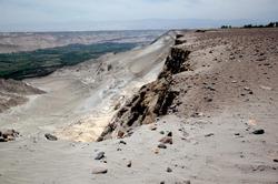
The Vitor Valley, in Arequipa, Peru, is saddled with a set of natural and related anthropogenic conditions which threaten its survivability in the medium term (Ponce, 2008). The natural condition is the region's unique geological and geomorphological setting: a succession of slightly undulating flatlands cut by deeply incised valleys. The anthropogenic condition is the valley-side slope slides, which can be traced to the irrigation return flows (Fig. 1). Seepage originating in excess waters from irrigation renders the high slopes unstable, with wide-ranging impacts.
|
The problem dates back to the onset of irrigation. After more than 40 years of inaction, the situation is now becoming untenable. Many valley-side slides are in progress and out of control in the Vitor Valley, with dire environmental consequences expected (Ponce, 2008). Thus, there is an urgent need for a strategic plan to solve the problem of the Vitor valley slides.
♦ BACKGROUND ♦
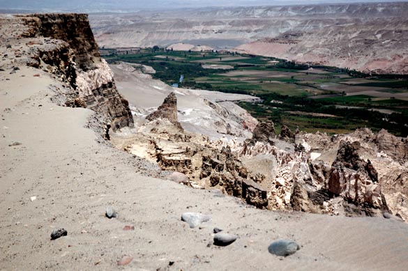
The southern coast of Peru was uplifted during the Tertiary Period and subjected to U-shaped valley cutting during the Quaternary. The uplift produced a geomorphological setting where large, slightly undulating flatlands, referred to locally as "pampas," dominate the landscape. In turn, the cuts have produced several deeply incised valleys which run from the Andes into the Pacific, among them, the Chili-Vitor-Quilca and the Colca-Majes-Camana. The elevation diference between the pampas and the adjoining valley floor is typically between 220 to 260 m (Fig. 2).

|
The river valleys of southern coastal Peru have been irrigated since ancient times. Recently, several irrigation projects have been developed in the pampas to take advantage of the fertile soils. These projects, among them La Joya and San Isidro-La Cano, convey water from upstream rivers for delivery to the pampas. Since the 1940s, these projects have transformed the superarid pampas into thriving agricultural regions, and they have been directly responsible for the creation of significant new wealth (Ponce, 2008). All the while, these improvements in social and economic development have had unforeseen environmental consequences. The irrigation projects did not include adequate drainage, either because it was not deemed necessary or because it was too costly. Irrigation without drainage is unsustainable; moreover, drainage without proper disposal produces negative impacts downstream (ASCE, 1990).
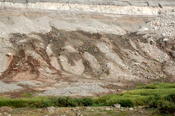
In the case of the Vitor valley and environs, the peculiar geomorphological setting acts to compound the problem. In a typical agricultural setting, the lack of natural drainage is resolved with artificial drainage channels. In the Vitor case there is no lack of natural drainage, the existing drainage head being quite sufficient. The problem at Vitor is the large head difference between the pampas and the valley floor. In practice, this means that any excess water in the pampas will have an urge to travel to the valley floor. If left uncontrolled, this flow will filter out in many places on the valley-side slopes (Fig. 3). Whether the stability of the slopes is to be affected by this situation cannot be predicted with certainty in any one location.
|
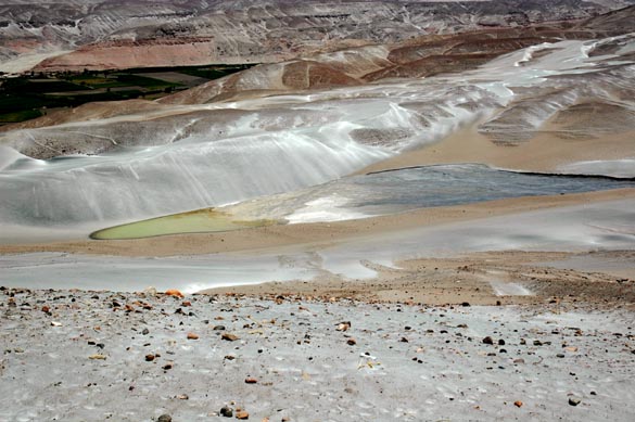
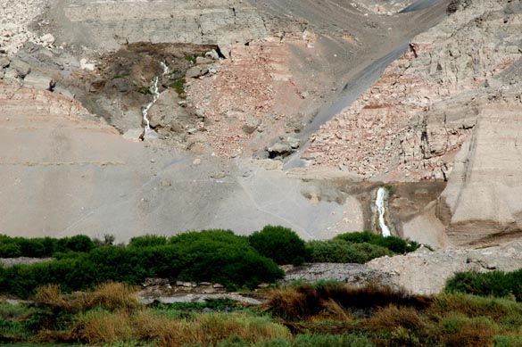
Over the years, irrigation return flows have had a negative impact on the valley slopes. There are currently four major valley-side slope slides in the Vitor valley. To this date, slope slides continue to recur intermittently in the Vitor valley, with no apparent end in sight (Ponce, 2008). Moreover, in many places water is seen to be seeping out of the ground to form lagoons at midslope elevations (Fig. 4).
|
♦ WHAT TO DO? ♦
The irrigations of La Joya and San Isidro-La Cano are producing a series of negative hydrologic and environmental impacts on the neighboring Vitor valley. A careful review of the facts will warrant this conclusion (Ponce, 2008). It is unrealistic to argue that the solution to this problem is to do away with irrigation. For better or for worse, irrigation will continue unabated because a way of life has already been established. If anything, the area under irrigation will increase as planned inter-basin water transfers make additional water available and more land is developed.
The question is how to solve the problem in a sound technical and economical way. The first thing that comes to mind is the replacement of gravity-fed irrigation systems for sprinkler and/or drip irrigation, in an effort to reduce the volume of return flows. However, water conserving sprinkler and drip-irrigation systems do not eliminate the return flows completely. The latter will always exist in some measure, because of the need to leach the soil profile from local and imported salts, resorting to the so-called "leaching fraction" (ASCE, 1990).
While water seepage is responsible for the slope slides, the problem appears to be not the water volume but the water path. Uncontrolled water will seep randomly and threaten the stability of natural earth slopes which are close to static equilibrium. Some slopes will become unstable and others will not. A case in point: There is an unusual waterfall in the Vitor Valley, formed at a location where a water seep encountered competent rock (Fig. 5). Other locations throughout the valley are not so lucky and certainly not as scenic.
|
Another approach when considering the possible alternatives is the drainage of the pampas and the controlled handling of the irrigation return flows. This is technically feasible, but its effectiveness is uncertain and the cost may be prohibitive. The problem in the Vitor valley is not lack of drainage, but lack of "proper" drainage. A suitable alternative may be to build a master drain that runs parallel to the slope, between the irrigation and the slope, to collect all subsurface waters before they have a chance to reach the vicinity of the slope.
Slope stabilization may actually compromise technical and cost considerations. A geotechnical stabilization of the affected slopes should work well in terms of stopping the slides while remaining as local treatment and, therefore, of limited cost. For example, a solution could be the installation of horizontal drains to release the pore pressure and convey the flows in a controlled fashion out of harm's way.
Given the complexity of the geologic profiles, experimentation may be used to determine the best way to effectively solve the problem. The most active slide (the Punillo slide) can be treated first and valuable experience gained in the process (Ponce, 2008).
♦ CONCLUSION ♦
The stabilization of the Vitor valley slopes involves a compromise between technical, economic, and environmental considerations. The agricultural drainage of the pampas is technically difficult and probably too costly. An alternative may be to build a master drain that runs parallel to the slope, between the irrigation and the slope, to collect most or all irrigation-return flows. The geotechnical stabilization of the most pressing active slides may also be a sound approach to cope with this anthropogenic problem, for which action is now long overdue (Fig. 6).
|